How StarSteer Enabled Digital Geosteering Transformation at Daqing Oilfield, Songliao Basin

Daqing Oilfield, located in Heilongjiang Province in northeastern China, is one of the largest and most historically significant oil fields in the world. Discovered in 1959 in the Songliao Basin, it became the cornerstone of China's petroleum industry and has been in continuous production for over six decades. At its peak, Daqing produced more than 50 million tons of crude oil annually, and it remains a strategic asset for China's energy security today.
After decades of conventional vertical-well development, Daqing's mature reservoirs face the universal challenge of declining production from easily accessible reserves. To unlock remaining hydrocarbons, particularly in tight oil, shale oil, and deep shale gas plays, the field has shifted aggressively toward horizontal drilling. Horizontal wells expose far more reservoir rock to the wellbore than vertical wells, dramatically increasing recovery while keeping development costs in check. In recent years, Daqing has rolled out large-scale horizontal well programs, making efficient and accurate geosteering a critical capability for the operator.
The work in this case study was carried out by Geological Logging Company No. 1, a unit under Daqing Drilling Engineering Company, the team responsible for real-time geosteering and logging operations across many of Daqing's horizontal well projects.
The Challenges
While Daqing had developed its own in-house geosteering software around 2019 — the “Large Displacement Horizontal Well Logging Geosteering Comprehensive Analysis System” — practical experience exposed several limitations as the field moved into more complex unconventional plays:
• Inability to model difficult reservoirs accurately. The in-house software struggled to build refined geological models for shale oil, tight oil, and high-difficulty horizontal wells where neighboring well data was limited. Without an accurate pre-drilling model, the geosteering team was essentially flying blind into complex formations.
• Reactive rather than predictive. Formation dip, the angle at which rock layers tilt underground, could only be calculated accurately after the drill bit had already reached or passed the reservoir boundary. By then, corrective adjustments came too late, reducing the percentage of the wellbore that actually stayed inside the productive zone.
• Gamma-ray modeling fell short in shale. In shale oil reservoirs, gamma-ray signatures and gas readings show minimal variation between layers, making it extremely difficult to distinguish rock types using traditional gamma-based modeling alone.
• Slow performance and limited functionality. Compared to international software, the in-house tool lacked horizontal-vertical linked fitting capabilities, ran more slowly, and could not deliver the real-time responsiveness modern geosteering demands.
• Disconnected data flow between field and office. The drilling crew at the wellsite had no efficient way to share live data with senior expert teams back at headquarters. Critical decisions were delayed while data was manually transferred, eroding the speed advantage that real-time geosteering is supposed to provide.
• Trajectory control issues during build-up sections. Tool face oscillation and uncertainty during the curved portion of the well, where the trajectory transitions from vertical to horizontal — created additional risk of missing the target reservoir.
The Solutions
Beginning in 2019, Daqing introduced StarSteer, an internationally recognized geosteering software, and over the following years built a complete digital workflow around it covering pre-drilling, mid-drilling, and post-drilling phases.
1. Multi-attribute pre-drilling geological models
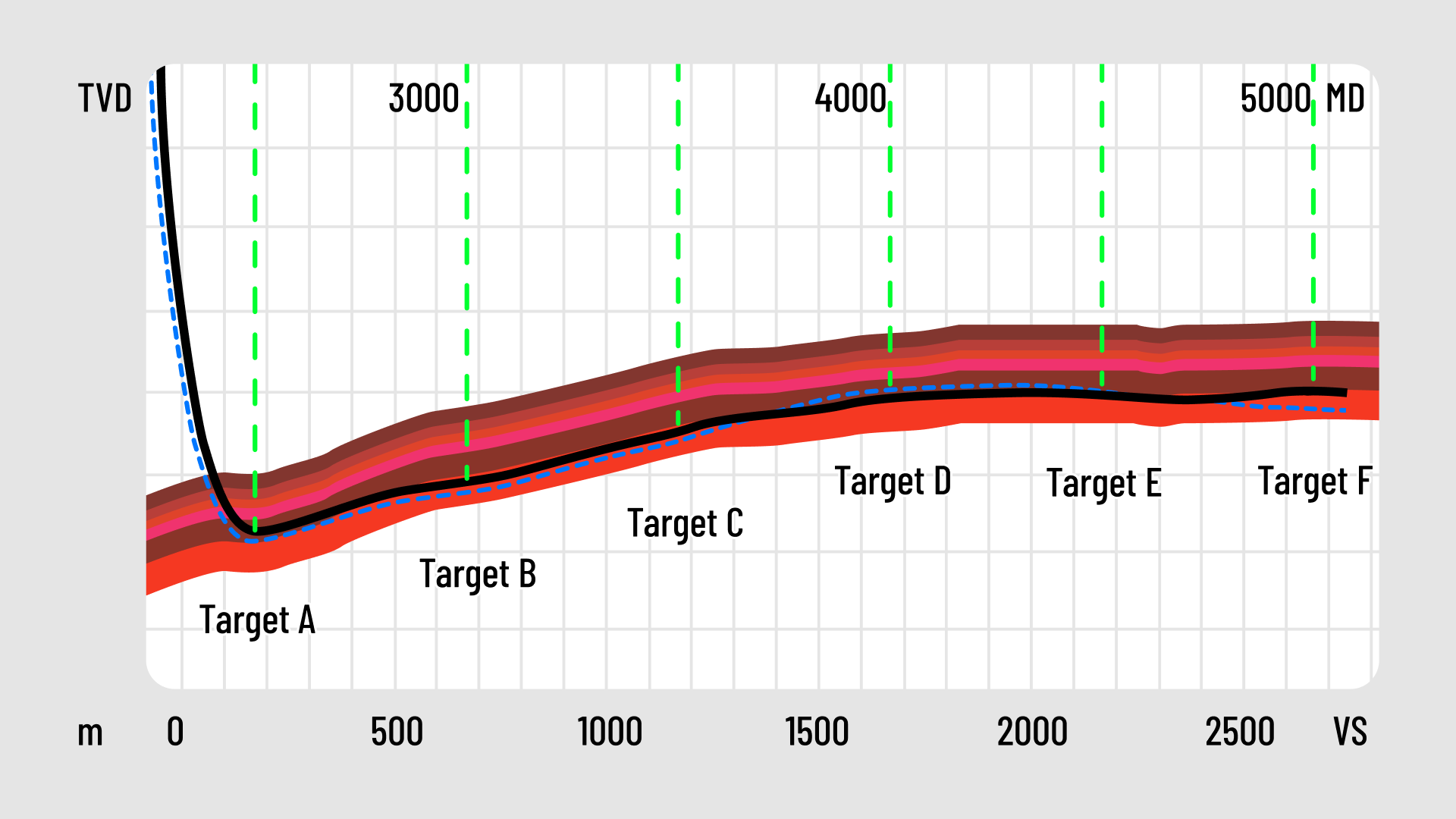
Rather than relying on a single data source, the team integrated seismic data, multiple logging parameters, regional reference wells, and elemental analysis into StarSteer to construct a comprehensive 2D geological model. The resulting model captured structural information, lateral reservoir development, and multiple rock attributes —providing a far richer “map” before the drill bit ever touched the ground. Figure 1 below shows an example of such a multi-parameter 2D geological model built in StarSteer, displaying the planned trajectory through the target reservoir.
2. Segmented prediction by inclination angle
To address the build-up section problem, the team divided the trajectory into eight inclination ranges (0–10°,10–20°, and so on up to 90°). For each range, they pre-determined expected lithologies and elemental signatures — calcareous mudstones, shell limestones, laminated shales, calcium and magnesium markers, and so on. This gave the geosteering team a predictive cheat sheet showing what rocks to expect at every stage of the build-up curve, eliminating much of the guesswork during the critical curved section of the well.
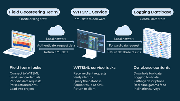
3. Real-time data synchronization via WITSML
The team implemented WITSML (Wellsite Information Transfer Standard Markup Language), an XML-based open standard for oilfield data exchange. By deploying WITSML services, they built alive data channel connecting StarSteer with the MWD/LWD downhole instruments and synchronizing field data directly to expert teams at headquarters. This eliminated waiting time, allowed back-office specialists to weigh in on decisions instantly, and created a true digital wellsite environment. Figure 2 illustrates the remote data synchronization workflow, showing how the field geosteering team, the WITSML service, and the central logging database connecting real time.
4. Integration with domestic rotary steering tools
Daqing's self-developed rotary steering system was paired with StarSteer to deliver two phase-resistivity measurements, four azimuthal gamma readings, near-bit real-time inclination, and spot inclination surveys, feeding StarSteer with the rich, real-time data needed for accurate model updates while drilling.
5. Three-party collaborative workflow
Roles were clearly defined: the Instrument Engineer manages tool operations, the Directional Engineer controls trajectory adjustments, and the Geosteering Engineer analyzes geological data and issues steering recommendations. Live measurement data flows directly to the geosteering engineer's workstation, who then communicates instructions to the directional engineer for execution, a clean handoff that prevents miscommunication during high-pressure drilling decisions.
The Outcome
The transition from a purely in-house solution to a StarSteer-based digital workflow gave Daqing's geosteering teams the predictive insight, real-time responsiveness, and collaborative infrastructure needed to drill complex shale oil, tight oil, and deep shale gas wells with significantly greater confidence. Pre-drilling models became more accurate, in-drilling decisions came faster through seamless field-to-office data sharing, and trajectory placement improved — all of which translates directly to higher reservoir contact rates and faster, more cost-effective well delivery.
For Daqing — a mature field whose future depends on extracting harder-to-reach unconventional reserves —this digital geosteering transformation is more than a software upgrade. It isa foundational capability for the next era of the field's productive life.
Source
LiMing, Wang Zhihui, Li Zhaolong. “Research on Application Technology of StarSteer Geosteering Software in Daqing Oilfield.” Western Prospecting Engineering, 2023, Issue 10, pp. 113–116. Article ID:1004-5716(2023)10-0113-04.


