All Data, Every Application, and the Entire Team in One Space.

We provide software solutions for geology, drilling, and completions teams to use on a customized cloud-based platform

About Us
Data Manager screenDrillSpot Analytics Dashboard
StarSteer - geosteering & geoscience softwareStarSteer geosteering & geoscience softwareStarSteer geosteering & geoscience software. Stochastic InversionStarSteer geosteering & geoscience software. Stochastic Inversion
ROGII's clientsROGII's clients

U-zontal Wells: Seamless Comm. Between Geosteerer and Directional Driller

Join Igor Kuvaev from ROGII Inc. and Daniel Wessel from INNOVA Drilling as they discuss U-zontal Wells: Seamless Communication between geosteerers and directional drillers.

Register here
March 19, 2024

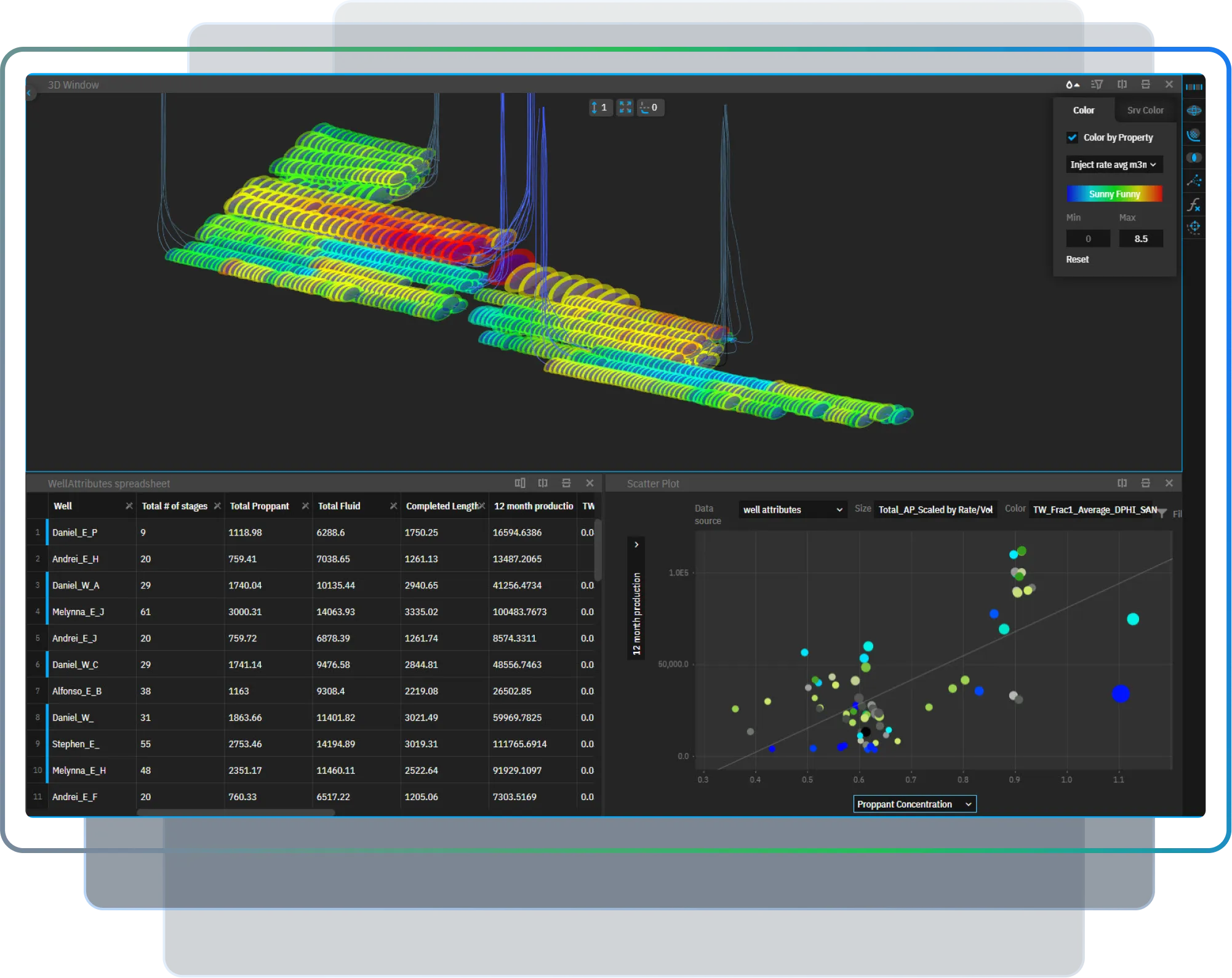
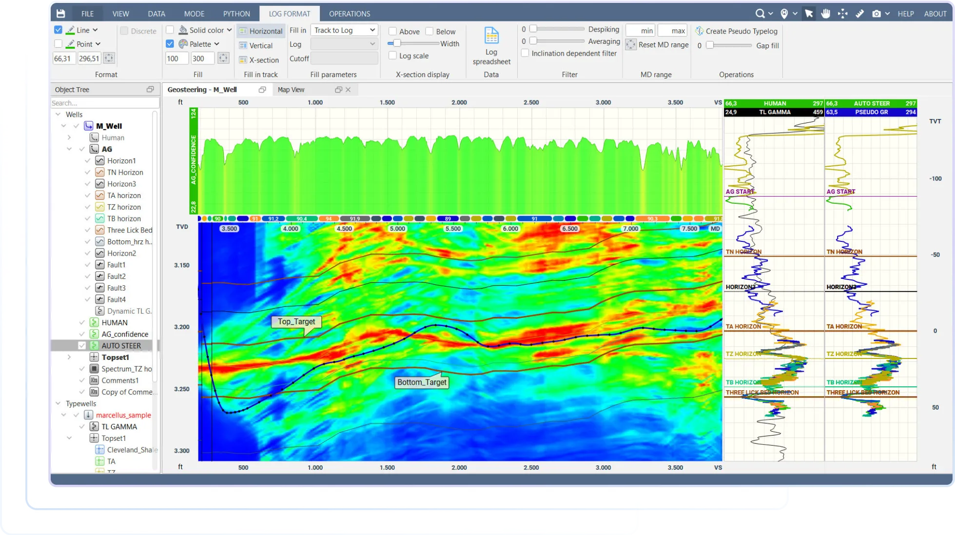
When you have the most advanced geoscience tool used for any geosteering purpose, you can efficiently steer a well with a high in-zone percentage and simulate the geometry of your reservoir with various angles of inclination and faults with up to 100% reliability.

StarSteer does it all!

StarSteer- Geoscience & Geosteering Software. Heat Map

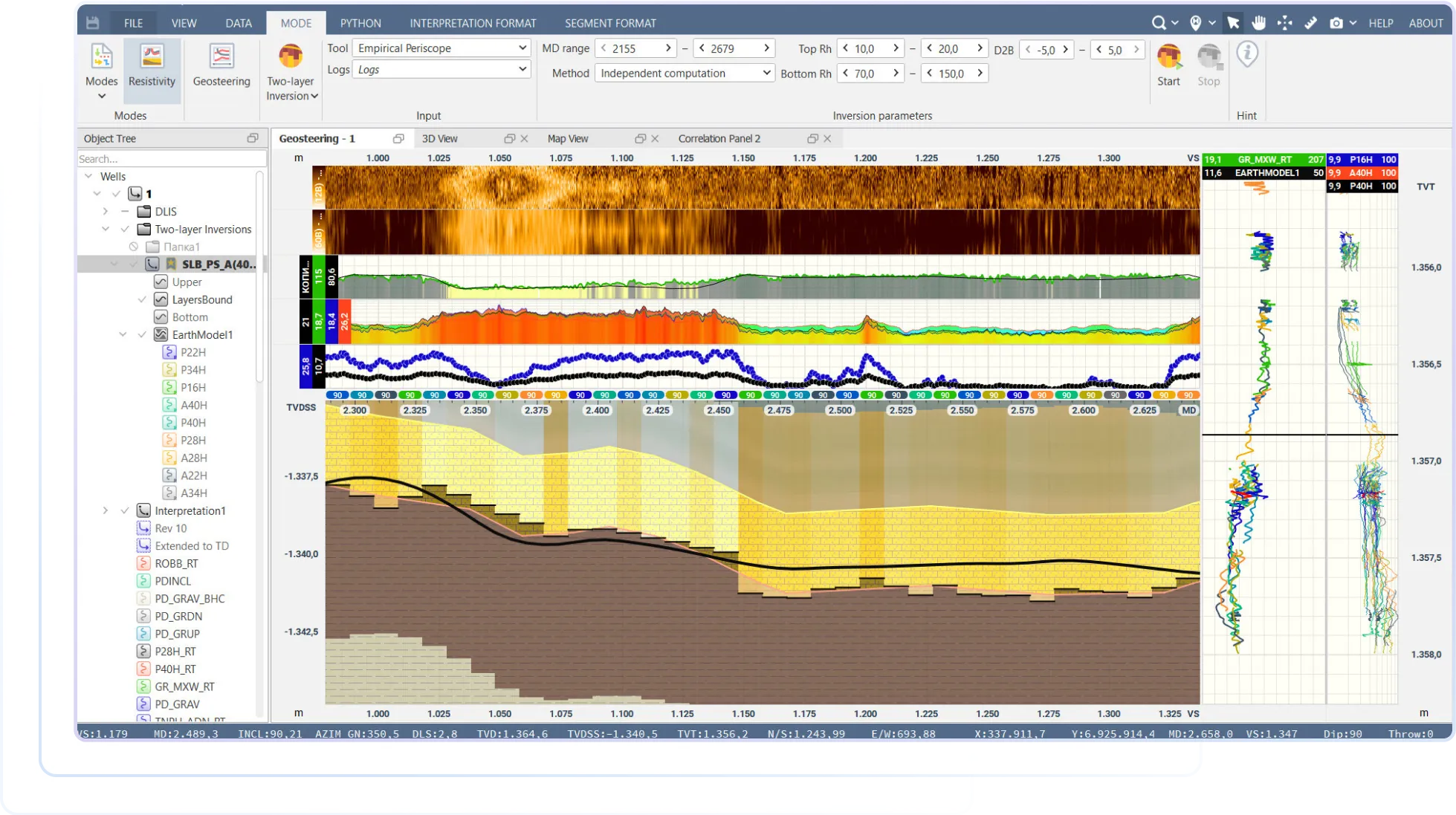
Sometimes the gamma ray contrast in your target zone is muted and unsuitable for geosteering. To avoid the risk of exiting the target zone, join the growing group of StarSteer users who are generating multi-layer Bed Boundary Mapping in real time!

In order to determine the position of the Oil Water Contact, StarSteer offers a unique, Vendor-Independent, Multilayer and Stochastic Reservoir Mapping Technology to help you keep your well in zone.

StarSteer- Geoscience & Geosteering Software. 2-Layer Well Boundary Detection

StarSteer's Auto Steer Tool makes geosteering easy. It's machine learning algorithm is trained on 1000s of wells across numerous reservoirs.

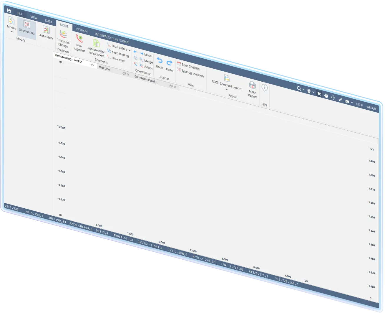
Users can also quickly and easily take formation tops from one well and automatically pick the same tops across any number of wells in the correlation panel!

StarSteer- Geoscience & Geosteering Software. Heat Map

Geosteering.

Resistivity.

Automation.

Drilling Monitoring and Optimization

DrillSpot - Well Drilling Monitoring and OptimizationDrillSpot - Well Drilling Monitoring and OptimizationDrillSpot - Well Drilling Monitoring and OptimizationDrillSpot - Well Drilling Monitoring and Optimization. Drillers Correlation PanelDrillSpot - Well Drilling Monitoring and Optimization. DrillSpot - Well Drilling Monitoring and Optimization. Drillers Correlation PanelDrillSpot - Well Drilling Monitoring and Optimization. GeoTarget WidgetDrillSpot - Well Drilling Monitoring and Optimization. Driller's Correlation PanelDrillSpot - Well Drilling Monitoring and Optimization. AnalyticsDrillSpot - Well Drilling Monitoring and Optimization. AnalyticsDrillSpot - Well Drilling Monitoring and Optimization. Analytics
Drilling StatisticsGeosteering InterpretationsKPIWITSML StreamingParameter ComparisonLogs

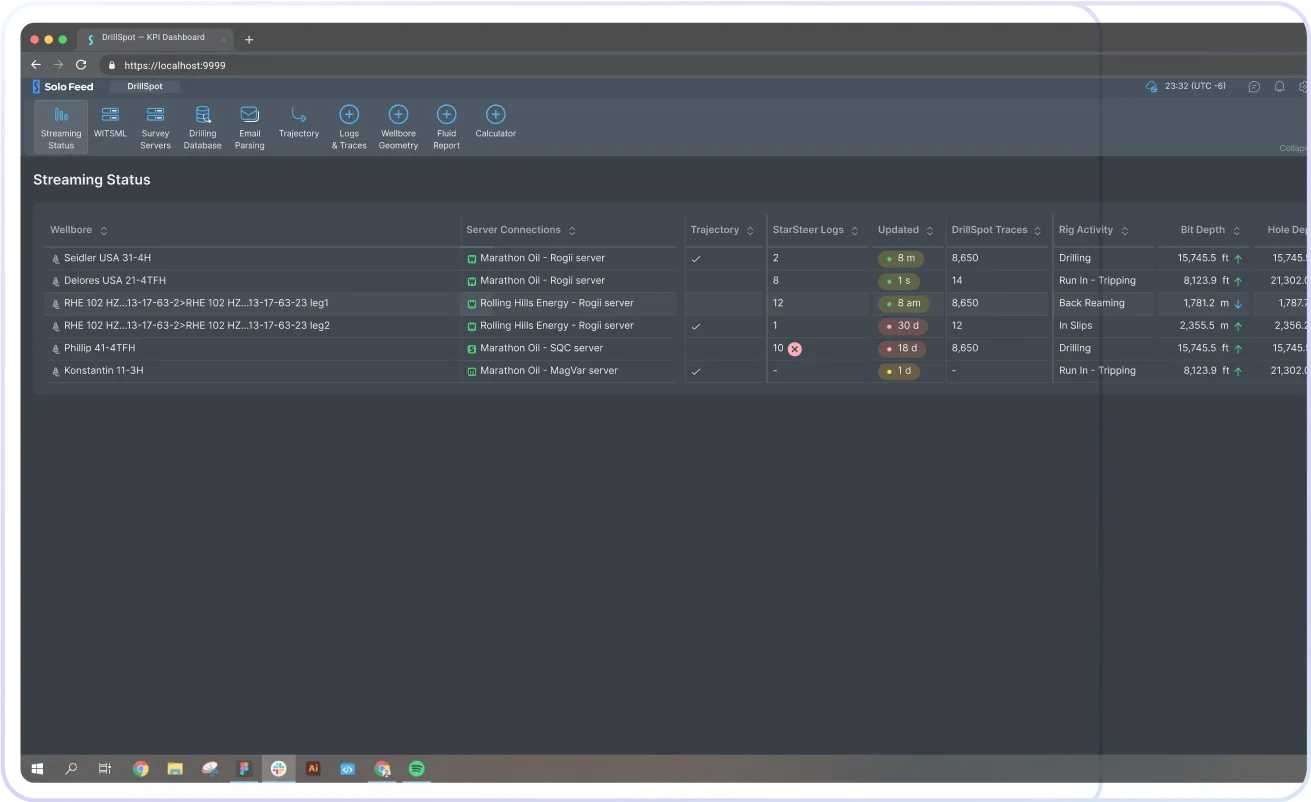
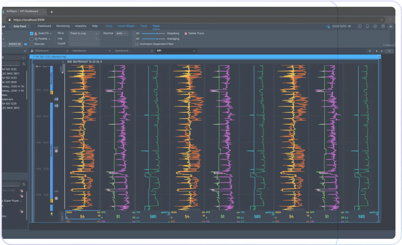
Display and analyze drilling data (time series and depth series) as well as other data types for drilling optimization and hazard detection.

Use DrillSpot analytical functionalities to enhance your decision making and customize data visualization!

DrillSpot - Well Drilling Monitoring and Optimization. Analytics Dashboard
Drilling Connection Time
DrillSpot - Well Drilling Monitoring and Optimization. GeoTarget Widget
GeoTarget Widget
DrillSpot - Well Drilling Monitoring and Optimization. Analytics Dashboard
Rig Activity Widget
DrillSpot - Well Drilling Monitoring and Optimization. Driller's Correlation Panel
Linear Widget
DrillSpot - Well Drilling Monitoring and Optimization. Analytics Dashboard
Rig Activity Widget

Cloud Data Management

Bring all data from each team into one central, organized location. No more duplicating files and migrating data from one source to another.

Quick, safe, simple with Solo Cloud!

Solo Cloud - A Cloud Solution Designed for Today's Oil & Gas IndustryReal-Time Data Aggregation.
WITSML™ Streaming, Reimagined.Seamless Data ConnectionsGeosteering & Geoscience Software Real-Time Drilling Monitoring, Analytics, and Optimization
Geosteering on the Go
Data Management Made Easy
Store, manage and visualize an unlimited number of wells on Google Maps.

Data
Analytics

How can you use all your geosteering, drilling, and other geoscience data from previously drilled wells?

With 4Cast, Solo Connect, and Python SDK you can use your data to analyze your asset, plan future wells and assess performance within your development area.

Production Forecast Modelling

Use 4Cast to integrate countless variables for modelling and forecasting future production with machine learning algorithms!

Gain a better understanding of which variables are most impactful on your production by automatically analyzing properties of the relevant wells.

01
Plan New
Wells

Integrate Geosteering interpretations with your Completions and Production data to plan new development.

Plan development locations in Map and Gun Barrel view in seconds using simple handy stick attributes.

02
Seamless Data Connections. Connect ensures any data stored in Solo Cloud can be connected to 3rd Party or internal databases for an evergreen data stream.